Bridging the Perimeter: Expanding TAK Situational Awareness to VOADs and volunteer response organizations
Situational Awareness for VOADs and Volunteer Response Organizations: Balancing Visibility with Operational Security
In a major crisis, disaster response is a whole-community operation. While public safety agencies assume responsibility for incident command and response, volunteer groups and external support teams are indispensable. Effectively coordinating dozens of government, nonprofit, volunteer, and private-sector entities requires a unified common operating picture, yet it must be achieved without compromising operational security or officer safety.
By leveraging the complementary capabilities of the Team Awareness Kit (TAK) and Bridge4PS, Texas public safety agencies and Volunteer Organizations Active in Disaster (VOADs) can achieve a new standard of controlled, one-way situational awareness.
Disaster Response as a Whole-Community Operation
Emergency management does not exist in a vacuum. Aligning with FEMA’s whole-community approach to emergency management, successful disaster response relies on integrating a diverse network of community resources.
During an incident, critical roles are played by a wide array of support partners, including:
- VOADs and other volunteer response organizations
- Transportation and public works crews
- School district personnel and utility teams
- Railroad representatives and critical infrastructure partners
VOADs and other volunteer response organizations may be conducting search and rescue, water rescue and evacuations, disaster reconnaissance, emergency communications, logistics and transportation, damage assessments, sheltering and feeding, supply distribution, debris operations, or other critical missions alongside government responders.
While public safety sets the incident strategy, these essential entities handle crucial functions ranging from field operations and mass care to logistics and infrastructure restoration. For incident commanders, knowing where these resources are located is vital to making better-informed, timely decisions.
The Team Awareness Kit Access Dilemma
The Texas TAK server serves as the state’s public safety geospatial environment, providing shared maps, real-time tracking, and operational overlays. Because it contains highly sensitive public safety locations and operational information, volunteer groups and non-governmental entities are not provided direct access to the server.
This creates an operational dilemma: how can incident command track these support groups on the main situational awareness map without giving them access to the broader, sensitive TAK environment?
Controlled Visibility Is Better Than Universal Access
Public safety executives no longer have to compromise operational security for the sake of convenience. The solution lies in a fundamental principle: controlled visibility is superior to universal access.
Different response participants have different operational needs. Agencies can now separate the need to contribute information from the need to consume it.
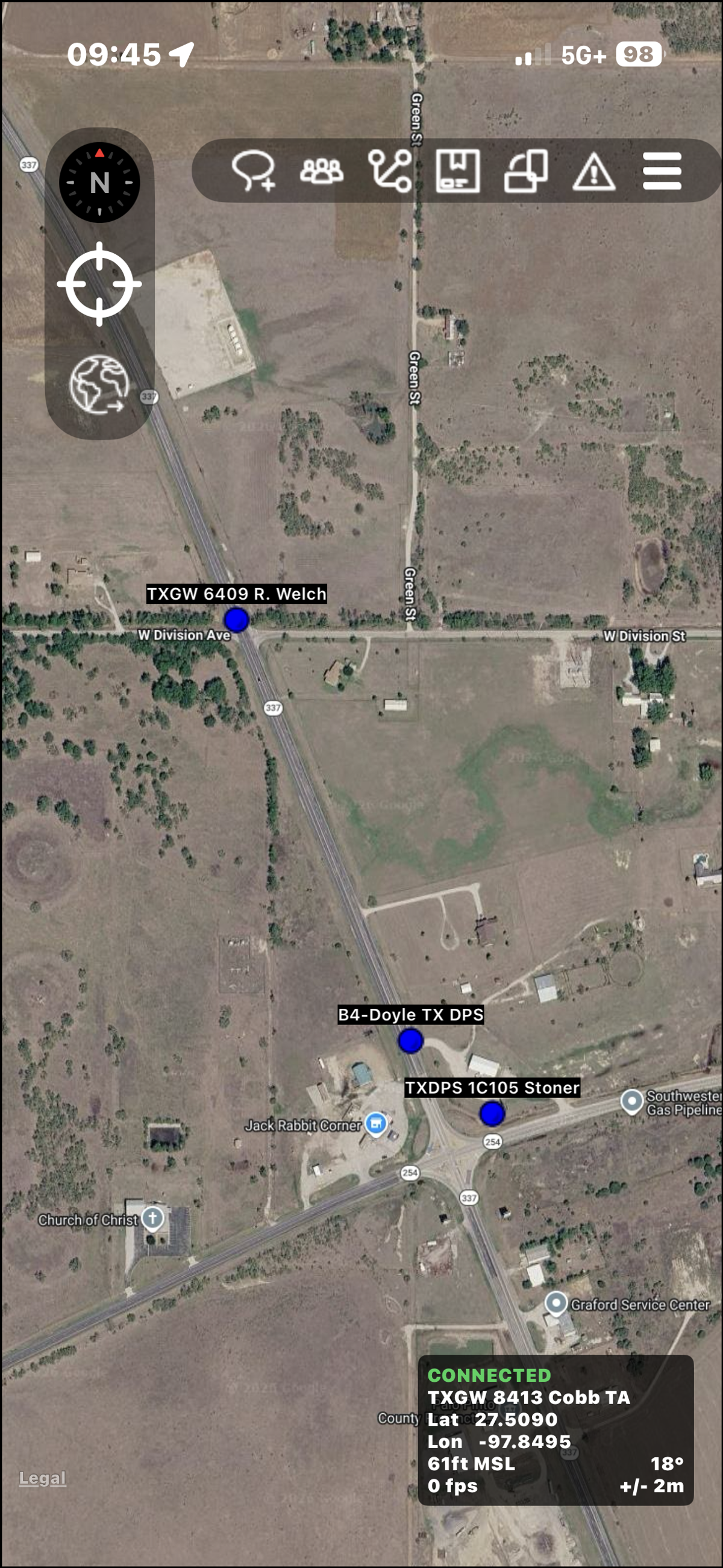
Through Bridge4PS, public safety can securely ingest the locations of authorized external support personnel into the public safety-only TAK map. Incident command gains greater visibility into the support resources deployed across the field, but those external partners cannot see public safety personnel, law enforcement assets, sensitive staging areas, or the broader TAK common operating picture. The information needed by TAK crosses the boundary. Access to TAK does not.
The Solution: One-Way TAK Location Sharing Through Bridge4PS
Bridge4PS features an innovative location services integration that safely bridges the gap between external partners and Texas TAK. Appropriately authorized VOAD personnel and support partners can use the Bridge4PS app to share their real-time location.
This configuration establishes a secure, one-way data pipeline:
- No TAK Account Required: Volunteer responders do not need a TAK account or access certificates.
- One-Way Mapping: Location data is shared from the authorized Bridge4PS channel into the configured TAK server environment.
- Strict Separation: The volunteer appears as a visible resource on the incident commander’s map, but the volunteer receives no reciprocal access to the TAK environment or public safety locations.
This capability builds on Bridge4PS’s broader integration with TAK and its ability to expand situational awareness beyond personnel who actively use the TAK application. Learn more about how Bridge4PS is expanding situational awareness beyond active TAK users.
Built for Secure, Cross-Boundary Collaboration
Bridge4PS was architected from the ground up to support cross-boundary collaboration while preventing accidental oversharing. Originally developed with funding from the U.S. Department of Homeland Security Science and Technology Directorate, Bridge4PS has years of experience supporting collaboration across agencies, jurisdictions, disciplines, and operational boundaries.
It functions as a secure workspace where public safety officials and vetted VOADs can communicate safely.
Security controls are built directly into the platform’s channels and workspaces:
- ✓No Automatic Tracking: Bridge4PS never automatically shares a user’s location simply because they are using the platform. Location sharing is optional, must be enabled for the specific operational channel, and also requires the individual user to enable location sharing within the Bridge4PS app.
- ✓Sponsored Access Only: Unaffiliated or spontaneous volunteers are never eligible for this integration. Public safety organizations must explicitly sponsor non-public safety users who have a verified operational need
- ✓Restricted Roles: Sponsored users are assigned restricted roles and must be manually added to specific response channels.
These controls are particularly important in a whole-community response. The goal is not to place every participant inside the same technology environment. It is to give each participant the access necessary to perform their mission while protecting information they do not need.
Enhancing the Mission Beyond Location Services
Bridge4PS does not replace TAK. TAK remains the geospatial authority for authorized public safety users. Instead, Bridge4PS serves as the secure connective tissue across organizational boundaries.
Beyond one-way location sharing, Bridge4PS provides dedicated collaboration channels where public safety and authorized VOAD partners can text, pass operational updates, coordinate logistics, and exchange situational data safely. This integrated approach preserves critical operational boundaries while assembling a more complete, whole-community response picture when Texas needs it most.
That distinction becomes increasingly important as disaster response grows more complex. A volunteer search-and-rescue team may need to communicate directly with emergency management and share its location. A transportation crew may need to coordinate access to a damaged roadway. A utility team may need to work alongside public safety personnel in a restricted area. None of those operational requirements automatically means those participants need access to the entire TAK environment.
Bridge4PS provides a way to connect them to the operation without unnecessarily expanding the security perimeter.
“During a major disaster, we need visibility into all of the resources supporting the response, not just the personnel who already use TAK. Bridge4PS gives us a way to see authorized volunteer and support resources on the TAK map while maintaining the security boundaries around our public safety environment. That gives incident command better situational awareness without expanding access to sensitive operational information.”
Texas Is Building an Integrated Model
Texas is demonstrating how TAK and Bridge4PS can work together as complementary components of a broader statewide interoperability strategy.
TAK provides the mapping and common operating picture. Bridge4PS provides secure real-time collaboration and a verified public safety network connecting agencies, disciplines, and jurisdictions. The integration allows those capabilities to reinforce one another while also creating controlled pathways for appropriately authorized support partners.
The model recognizes an important operational reality: not everyone who needs to contribute to situational awareness needs to become a TAK user.
For states and agencies evaluating how to expand situational awareness across increasingly complex disaster response environments, Texas provides a practical example of how collaboration, identity, mapping, and controlled access can work together.
Read more:
This approach also aligns with FEMA’s whole-community emergency management framework, which recognizes that effective preparedness and disaster response require participation from government, community organizations, nonprofits, businesses, and individuals.
Frequently Asked Questions
Ready to strengthen your team's communication security?
See how Bridge4PS can transform your emergency response coordination with secure, compliant messaging built for public safety.